A game changer for faster and better flood emergency response in Myanmar

By using extensive data, the MIMU flood monitoring dashboard is designed to answer when the flooding takes place, where it occurs and who has been affected.
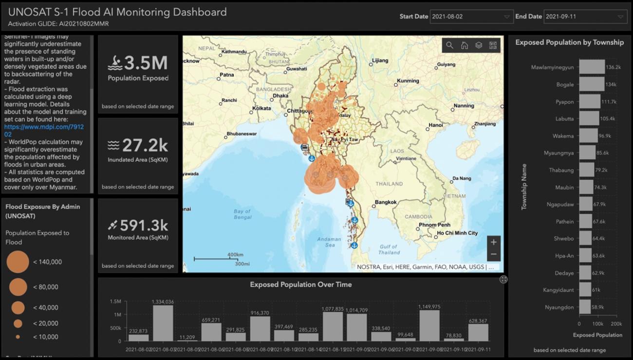
For the first time, extensive data on flooding in Myanmar has been made available through the United Nation’s Satellite Centre’s (UNOSAT) Flood Monitoring Dashboard on the Myanmar Information Management Unit (MIMU) website. The Dashboard uses satellite data to rapidly map likely flood-affected areas and estimate the populations at risk to support faster, better-targeted flood emergency response. Launched in August 2021, it will remain as a permanent tool on the MIMU platform to track and monitor the flood situation for the remainder of the 2021 monsoon season and beyond.
The monsoon season is a double-edged sword for the people of Myanmar. While it brings essential freshwater for agriculture and domestic use, it can also cause flooding and the displacement of thousands of people around the country. In the past, floods have displaced and destroyed the livelihoods of hundreds of thousands of people in Myanmar – the 2021 monsoon season alone has caused severe destruction affecting as many as 125,000 people since 21 July.
Knowing when, where and how many people may need support leads to a faster response and the potential to save more lives and livelihoods. Previous methods of mapping flood-affected areas were based on semi-automated processes requiring hours or even days to get the results. The fully-automated method behind this Dashboard combines extensive historical records of flood data with new technologies, producing maps of affected areas in a fraction of the time as essential information for rapid response on the ground.
In this process, potentially flooded areas of Myanmar are constantly monitored. As soon as a flooding is detected, the inundated area is mapped and the estimate of affected population is calculated using population estimates collated by WorldPop. The data is then assembled into a user-friendly interactive dashboard on the MIMU website.
The Dashboard is designed to answer three important questions:
When did the flooding take place?
The Dashboard shows the cumulative data starting from 2nd August, 2021, up to the latest available date. The start date and end date boxes on the top right allow users to selectively examine the flooding situation in a given period.
Where did the flooding occur?
The inundated areas are displayed on the map and the total area is also shown. A bar chart summarizes the townships with the most affected populations in the selected period.
Who has been affected?
The total potentially affected population is shown as well as summarized in the bar chart at the bottom. The map also visualizes the exposed population as circles whose size is proportional to the number of people affected.
The ability to download the data as shapefiles is an advanced feature and the files can be imported into geographic information system (GIS) software to create custom maps and analyses.
As with any remote sensing exercise, the Dashboard comes with its own sets of caveats. Flood analysis may significantly underestimate the presence of standing waters in built-up and/or densely vegetated areas. Flood extraction was calculated using a deep learning model1 and the population affected by floods in urban areas may be significantly overestimated. That is why confirmation on the ground is always valuable and humanitarian and development agencies are encouraged to send feedback on the actual flooded areas to MIMU or UNOSAT.
Natural disasters usually have the biggest impact on the country’s most vulnerable population and millions of people in Myanmar continue to live under the threat of the flooding as the most common natural disaster. By using the latest technology, the UNOSAT Flood Monitoring Dashboard provides an accessible tool for users’ information, monitoring, and decision-making purposes.
The UNOSAT Flood Monitoring Dashboard along with flood maps and other useful resources can be found in the MIMU’s Monsoon flooding 2021 page.
The Myanmar Information Management Unit (MIMU) is a service of the United Nations Resident and Humanitarian Coordinator to support the information management needs of humanitarian, development, and peace-focused actors across Myanmar for analysis and decision-making.
References
Thar, Chan. 2018. Myanmar people struggle amid floods. August 7. Accessed September 15, 2021. https://www.mmtimes.com/news/myanmar-people-struggle-amid-floods.html.&…;
UNOCHA. 2021. Myanmar Humanitarian Update No. 10. Yangon: UNOCHA.
Edoardo Nemni, Joseph Bullock, Samir Belabbes, Lars Bromley. 2020. "Fully Convolutional Neural Network for Rapid Flood Segmentation in Synthetic Aperture Radar Imagery." Remote Sensing 12 (16): 2532.
UNOSAT. 2020. UNOSAT INTRODUCES AI IN ITS FLOOD RAPID MAPPING OPERATIONS FOR THE BENEFIT OF NATIONAL DISASTER MANAGEMENT AUTHORITIES. August 31. Accessed September 15, 2021. https://unitar.org/about/news-stories/news/unosat-introduces-ai-its-flo…;
Shannon Doocy, Amy Daniels, Sarah Murray, Thomas D. Kirsch. 2013. "The human impact of floods: a historical review of events 1980-2009 and systematic literature review." PLOS Currents: Disasters.
Written by


